

LIVING HERE
How Thick Does Ice Need to Be To Walk and Drive On?
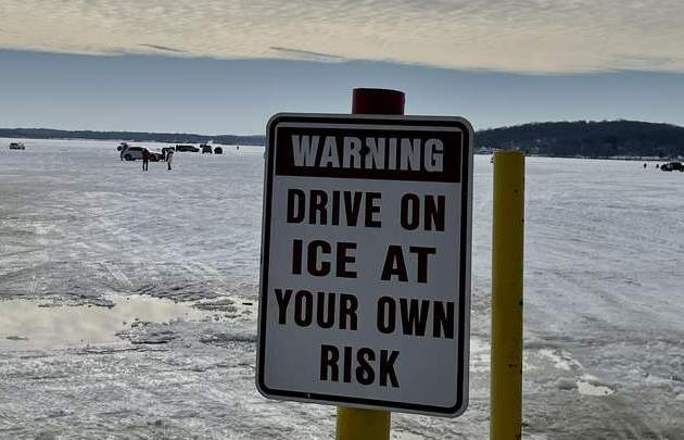
One of the most important things to remember is that ice is never 100% safe. Bodies of water do not freeze uniformly. Ice can be 2 feet thick in one place and just a few inches thick a few yards away. In addition, snow cover, currents, and other factors can affect the thickness and stability of ice. While the thickness of the ice can give you a general guideline, you can’t rely on the thickness alone since many other factors also affect ice strength. Clear ice or new ice is the strongest type of ice. If the ice is white, cloudy, or milky, double the safety measurements. Ice with slush on top is not safe. It may mean that the ice is not freezing from the bottom. Avoid areas of ice with logs or other protruding debris. Even just a few days of warmer temperatures can cause cracks to form, weakening the ice around them.
Because ice conditions vary, it is important to know before you go. The DNR does NOT monitor local ice conditions or the thickness of the ice. So, how thick does ice need to be to walk on it safely? This general gauge gives safe ice thicknesses to support different types of activities: less than 4 inches, stay off the ice. 4 inches: walking, ice fishing, ice skating, or other activities on foot are permitted. Safety tips: Dress warmly in layers. Don’t go alone. Head out with friends or family. Take a cell phone if available, and make sure someone knows where you are and when you are expected to return. Know before you go. Don’t travel to areas you are not familiar and don’t travel at night or during reduced visibility. Avoid inlets, outlets, or narrow areas that may have current that can thin the ice. Look for clear ice, which is generally stronger than ice with snow on it or bubbles in it. Carry some basic safety gear: ice claws or picks, a cellphone in a waterproof bag or case, wear a life jacket at all times, and have a bit of rope.
Ready to kiss winter goodbye?
This past year has been full of weather ‘weirdness,’ or wild shifts in weather conditions like swings from rainfall to drought and it has continued into 2024. We went from barely any snow in November or December to two snowstorms, and an ice storm in the first weeks of January which also brought days of frigid temperatures. We can’t forget the dense fog that lingered for days with visibility of 1/8 of a mile at best. Then temps warmed up to the point that Winterfest might suffer from the blocks of snow and ice melting before they could even be carved or displayed. Warmer temperatures allow the atmosphere to hold more water and exacerbate precipitation events like rain or snow with last week being the perfect example being full rain and gloom.
We may not have spring yet, but in the meantime, the amount of daylight we have each day will continue to slowly increase. Daylight Saving Time begins the second Sunday in March and ends the first Sunday in November. The first day of spring is March 19th, and here’s what to expect. Wisconsin is expected to see temps warmer than normal this Spring during February, March, and April. Warm-weather predictions are in part due to El Niño, a natural climate pattern that sends temperatures soaring. The jury’s still out on whether Phil, the groundhog, will predict an early spring as well.


